Brandywine Creek || Christina River || Naamans Creek || Red Clay Creek || Shellpot Creek || White Clay Creek
White Clay Creek
Background The White Clay Creek watershed is one of four major watersheds in the Christina Basin. The Christina Basin is part of the Delaware River Basin. The White Clay Creek is a tributary of the Christina River and flows southward out of Pennsylvania and into Delaware near Newark. The northern portion of the watershed in Chester County, Pennsylvania includes the East, Middle, and West Branches of the White Clay Creek. The White Clay Creek flows southeast into New Castle County, Delaware and is joined by Middle Run and Pike and Mill Creeks before emptying into the Christina River. Lower portions of the White Clay Creek are under tidal influence. In 2000, the President signed a law adding 190 miles of the White Clay Creek and its tributaries to the National Wild and Scenic Rivers System. The White Clay Creek is the first Wild and Scenic River in the United States designated on a watershed basis rather than a river corridor. Collectively the White Clay, Red Clay, and Brandywine creeks and Christina River are used to supply drinking water to more than 50% of New Castle County's population. The surface water of the White Clay Creek and the aquifers in the watershed provide over 100,000 residents with drinking water. The White Clay Creek serves as a major drinking water source for much of northern Delaware. Delaware and Pennsylvania residents in the White Clay Creek watershed also receive a significant amount of their water supply from groundwater resources in the watershed. The Pennsylvania portion of the watershed is largely rural with a few small towns and villages, such as West Grove and Avondale, and some suburban clusters. The Delaware portion of the watershed includes the City of Newark and is highly suburbanized, although several very large tracts of public open space remain intact and flank the river.
Water Quality The nutrient and bacteria TMDLs for the Delaware portion of the White Clay Creek requires varied reductions based on the stream segment of between 0-62% reduction in nitrogen, between 0-77% reduction in phosphorus and between 29-95% reduction in bacteria. The zinc TMDL for the Delaware portion of the White Clay Creek Watershed requires a cap on zinc at 6.73 pounds/day. This watershed has sites sampled for a consistent suite of environmental contaminants. These contaminants are broadly classified as Volatile Organic Compounds (VOCs), Semi-Volatile Organic Compounds (SVOCs), Pesticides, Polychlorinated Biphenyls (PCBs) and Metals as listed using USEPA and DNREC defined standards. When sites are adjacent to water bodies sediment samples are collected to assess potential impact from a site on the health of the waters. Learn more information specific to this watershed from the DNREC Advanced Facility Search Tool.
Plants and Wildlife The watershed is home to a wide variety of fish and wildlife. Its waters support over 24 species of fish. The creek is stocked annually by both Delaware and Pennsylvania and is considered Delaware's premier trout-fishing stream. Surveys estimate that 93 species of birds nest in the watershed. Thirty-three species of small mammals have been documented in the watershed. Twenty-seven species of amphibians and reptiles live in the watershed, among them the rare bog (muhlenbergs) turtle. Botanical surveys have found over 500 plant species native to the watershed and more than 500 wild flowers including nine native orchids. Trees also contribute significantly to the area's character as tulip trees, sycamores, beeches, and oaks define the landscape. A survey of White Clay Creek State Park and Preserve found 24 Delaware 'species of special concern' and numerous plant species from Pennsylvania's endangered plants list. Delaware's Department of Natural Resources and Environmental Control (DNREC), Division of Fish and Wildlife conducts on-going inventories of natural communities as well as rare and declining species, (e.g., state and globally-rare plants, birds, insects, mussels, reptiles, and amphibians). It maintains a database, both electronic and manual, of its findings throughout the state. Learn more about the wildlife and plant communities in this watershed from the DNREC Division of Fish and Wildlife Conservation Programs. In addition, the Division of Fish and Wildlife, working with the University of Delaware's Institute for Public Administration - Water Resources Center, maintains online databases about plants and plant communities in Delaware. Learn more about the plant communities in this watershed from the DNREC Division of Fish and Wildlife.
Recreation and Culture Open space is a major platform for recreation in the White Clay Creek watershed. The White Clay Creek State Park and Preserve and numerous municipal and county parks provide hiking and biking trails for the community. The streams of the White Clay Creek are an extremely popular fishing destination in the tri-state region.
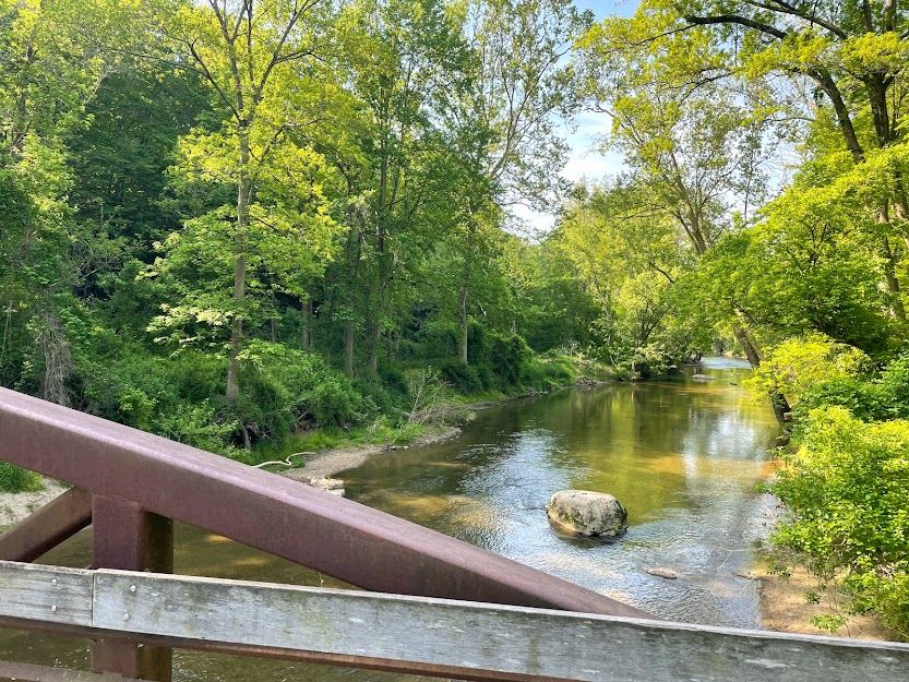
Further Resources For more detailed information on this watershed, its water quality and resources, check out the following resources: Delaware TMDLs White Clay Creek Association Chester County Water Resources Plans Delaware Watershed Plans Delaware Whole Basin Reports  View from the pedestrian bridge, White Clay Creek State Park, near Newark, DE. Photo credit: Andrew Homsey | Quick facts ▲ Square Miles (total): 107.3 Square Miles (DE): 46.2 Population (total)*: 125,773 Population (DE)*: 94,178 States: DE, PA, MD Counties: DE: New Castle PA: Chester MD: Cecil *Source: U.S. Census Bureau, American Community Survey 5-year estimates, 2019.
Land cover (total)† ▲
Land cover within Delaware† ▲ †Source: National Oceanic and Atmospheric Administration, Office for Coastal Management. 2016 C-CAP Regional Land Cover. Coastal Change Analysis Program (C-CAP) Regional Land Cover.. |